Geographical Atlas of Natural Disasters in Slovenia
Authors
Blaž Komac, PhD, Rok Ciglič, PhD, Mauro Hrvatin, PhD, Manca Volk Bahun, PhD, Lenart Štaut, Matija Zorn, PhD-
Period of creating
since 1983
Caretaker
-
Profession
Geography, Geology, and Karst studies
-
Publisher
-
ISSN (electronic edition)
3023-9613
The collection contains information on natural hazards and historical natural disasters in Slovenia for the most common types of natural disasters.
Link to the Geographical Atlas of Natural Disasters in Slovenia.
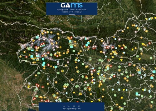
The Department of Natural Hazards at the ZRC SAZU Anton Melik Geographical Institute has created an online Geographical Atlas of Natural Disasters in Slovenia with the acronym GANNS, which aesthetically suggests the name GAMS. The atlas is dedicated to the 100th anniversary of the birth of the Slovenian geographer academician Prof. Ivan Gams.
The Atlas contains basic information on natural hazards and natural disasters in Slovenia. It includes data on historical avalanches, floods, landslides, earthquakes, forest fires and damage caused by natural disasters, as well as information on the hazard posed by these processes. The Geographical Atlas of Natural Disasters in Slovenia is one of the few collections of its kind. There are a few important online atlases around the world that show natural disasters by country, but few collections show the situation for a country's territory in such a complex way (26 categories) for the last hundred and fifty years.
Its aim is to inform the interested and general public about the types and frequency of natural disasters that have occurred on the territory of Slovenia since the 14th century, more frequently since 1750, and more specifically for the last 150 years, when newspaper sources are available. In total, it comprises approximately 5,000 units and contains just over 100,000 data, of which the relevant ones are displayed in the online GIS.
The Atlas is important for improving the knowledge of natural hazards in a given landscape, both for permanent residents and occasional visitors such as tourists and hikers. It is also the basis for space management, which includes both the construction of buildings and, in particular, critical infrastructure, such as roads in Alpine landscapes.
Due to their complex understanding of landscape processes geographers were among the first to study the most important natural hazards in Slovenia, with Anton Melik carrying out the first complex geographical study of floods after the Celje floods of 5 and 6 June 1954, Ivan Gams studying snow avalanches in the early 1950s (Gams 1955), and Drago Meze studying landslides in the 1960s. The first foundations of the atlas were also laid at the Anton Melik Geographical Institute of the Slovenian Academy of Sciences in the 1980s, as evidenced by archival material. Since 2017 these data have been updated, digitized and prepared for publication in an online atlas that is searchable and browsable. The Atlas is available as an online geographical information system at ganns.zrc-sazu.si since November 2023.
A description of the atlas in English is available here.
Reference of the scientific article about Geographical Atlas of Natural Disasters in Slovenia:
Komac, B., Ciglič, R., Hrvatin, M., Volk Bahun, M., Štaut, L., Zorn, M. 2023: Geografski atlas naravnih nesreč v Sloveniji / Geographical Atlas of Natural Hazards in Slovenia. Geografski vestnik 95-1. DOI: https://doi.org/10.3986/GV95105.
Acknowledgments
The Atlas was produced at the ZRC SAZU, GIAM, Department of Natural Disasters, in the framework of the research project Avalanche hazard management through terrain classification (J6-2591; 1 Sep 2020-31 Aug 2023; PL: Blaž Komac), and based on the work and data collected in the framework of the projects CapHaz-Net (Social capacity building for natural hazards; 2009–2012, ZRC SAZU PL: Blaž Komac), The impact of climate change on avalanches in Slovenia (J6-4627; 1 Oct 2022–30 Sep 2025; PL: Blaž Komac), Resilience of Alpine landscapes from the perspective of natural disasters (J6-6853; 1 Oct 2014-30 Sep 2017; PL: Blaž Komac), and Increasing the efficiency and applicability of the study of natural disasters with modern methods (L6-4048; 1 Jul 2011-30 Jun 2014; PL: Matija Zorn), Interreg projects (Natural Disasters without Borders – NHWF; 1 Oct 2011-30 Sep 2014; PL: Miha Pavšek; Crossrisk, 1 Jun 2018-31 May 2021, PL: Miha Pavšek) and the research programmes Regional Geography of Slovenia (P0-0515-0618; 1 Jan 1999-31 Dec 2003) and Geography of Slovenia (P6-0101; 2003-2027), as well as research and archives of the ZRC SAZU GIAM from the period before 1999.
Media publiations
- Slovenia gets 1st online atlas of natural disasters. Spotlight. Radio Slovenia.
- History of Slovenia's natural disasters mapped with interactive atlas. STA, Slovenian Press Agency, 9. 11. 2023.
- History of Slovenia's natural disasters mapped with interactive atlas. STA, Slovenian Press Agency, 9. 11. 2023.
- App maps natural disasters since 14th century. The Slovenia Times, 12. 11. 2023.
- Zlobec, M. 2023: Med punkom in naravnimi nesrečami (4). Kritik, Ljubljana.
- Gerden, T. 2024: Geographical Atlas of Natural Hazards in Slovenia. Interview: Rok Ciglič. Radio Slovenija - ARS.
- Komac, B., Ciglič, R., Hrvatin, M., Volk Bahun, M., Štaut, L., Zorn, M. 2023: Geografski atlas naravnih nesreč v Sloveniji / Geographical Atlas of Natural Hazards in Slovenia. Geografski vestnik 95-1. DOI: https://doi.org/10.3986/GV95105