The Life and Death of Cultivated Terraces: Computer-Based Recognition and Spatial Analysis of Terraces
Principal Investigator at ZRC SAZU
Rok Ciglič, PhD, Asst. Prof.-
Original Title
Življenje in smrt kulturnih teras: zaznavanje in prostorska analiza teras z računalniškimi metodami
Project Team
Mateja Breg Valjavec, PhD, Asst. Prof., Rok Ciglič, PhD, Asst. Prof., Luka Čehovin Zajc, PhD, Špela Čonč, PhD, Mateja Ferk, PhD, Matjaž Geršič, PhD, Mauro Hrvatin, PhD, Blaž Komac, PhD, Matej Kristan, , PhD, Lenart Štaut, Drago Perko, PhD, Jure Tičar, PhD, Filip Wolf, Matija Zorn, PhD-
ARIS Project ID
L6-60160
-
Duration
1 January 2025–31 December 2027 -
Lead Partner
Znanstvenoraziskovalni center Slovenske akademije znanosti in umetnosti, Geogra…
-
Financial Source
Slovenian Research and Innovation Agency

Slovenian Academy of Sciences and Arts

Partners
University of Ljubljana, Faculty of Computer and Information Science
BACKGROUND. Terraced landscapes are cultural landscapes of special significance. Cultivated terraces, which are often intended for farming, ensure food and have a priceless ecological, cultural, and historical value. Terraced landscapes are disappearing in places due to overgrowth or improper maintenance. In order to raise awareness of their significance, the Honghe Declaration was passed at the global level in 2010. Slovenia still has not managed to implement suitable criteria for terrace identification or introduce a comprehensive management system despite having officially recognized terraces as a valuable element for landscape preservation (see the Decree on Cross-Compliance, Official Gazette of the Republic of Slovenia, no. 97/2015). A precise overview (register) of the locations of cultivated terraces and spatial analyses are required as the foundation for any further measures.
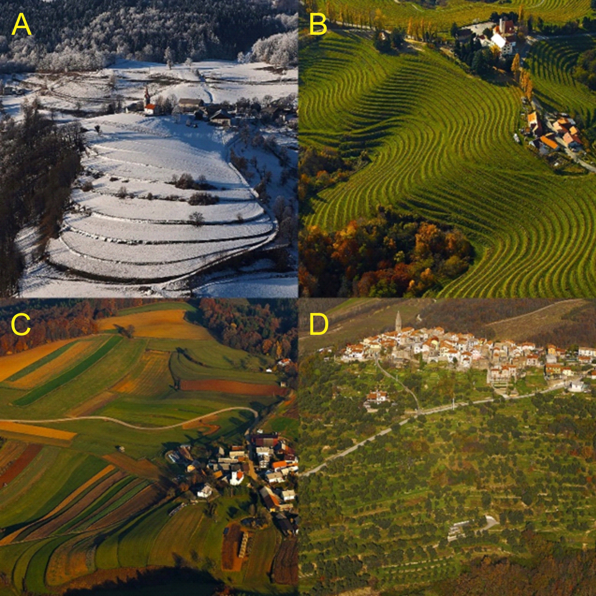
Figure 1: Examples of Slovenia’s terraced landscapes in the Alps (A), Pannonian Basin (B), Dinaric Alps (C), and the Mediterranean (D). Photos: M. Lenarčič.
GAP. Cultivated terraces in Slovenia have been manually documented and analysed based on the visual examinations of orthophotos, topographical maps, and fieldwork; however, this inventory is insufficient due to the lack of data and methodological limitations. Past studies have pointed to the diversity of cultivated terraces, but have not been able to provide definitive procedures for their more objective (and automatic) recognition and resulting sufficient studies of their geographical characteristics. This has undoubtedly become more feasible now than it was a few years ago due to new research techniques, e.g., the laser scanning of surface and machine learning. A review of past studies revealed that automatic cultivated terrace recognition based on a digital elevation model using advanced machine learning, such as deep learning, has practically never been attempted, not even at the global level.
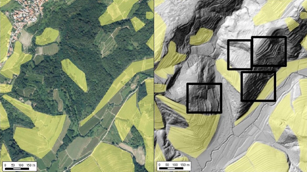
Figure 2: Example of terraces that haven’t been recognized and registered yet.
GOAL. The project aims to produce computer algorithms that will be able to largely automatically recognize cultivated terraces on the basis of digital spatial data. The new database of terraces will also include terraced areas that are currently missing from the database of terraces, especially those that have been abandoned and overgrown. To this end, the secondary aim is to gain a more complete insight into the terraces’ characteristics (e.g., morphometry and land use).
PROJECT AREA. Past studies have confirmed that Slovenia boasts extreme (terraced) landscape diversity even at the European level and is therefore a suitable environment for testing the recognition capabilities of terraces because it is possible to find diverse training and testing sets here. For this reason, cultivated terrace recognition will be carried out in different regions across the country. High resolution spatial data (e.g., DEM) availability is another argument in favour of selecting Slovenia as the research area.
PLAN. The project is divided into three stages: 1) the preparation and analysis of the input data and the training sets, 2) the preparation of models using established geoinformation methods and advanced machine learning (deep learning), and 3) the geographical analysis of the recognized terraced landscapes and terraces (e.g., morphometry).
CONTRIBUTION. The results will contribute to the improved catalogue of cultivated terraces in Slovenia as well as to the improved methodology for cultivated terrace recognition, which can be applied abroad. The project will bring understanding of the characteristics and usage of terraces, which can serve as the foundation for further research.
There are three main project stages:
1) the preparation and analysis of the input data and the training sets,
2) the preparation of models using established geoinformation methods and advanced machine learning (deep learning), and
3) the geographical analysis of the recognized terraced landscapes and terraces (e.g., morphometry).
Štaut, L., Ciglič, R., Repe, B. 2026: Slope-driven edge analysis of high-resolution LiDAR data for automated detection of cultural terraces in Slovenia. Hungarian geographical bulletin 75-1. DOI: 10.15201/hungeobull.75.1.4