The great Miocene barrier reef of southern Australia
Project Team
Matej Lipar, PhD, Asst. Prof., Mateja Ferk, PhD, Matija Zorn, PhD, Rok Ciglič, PhD, Asst. Prof., Jure Tičar, PhD, Lenart Štaut, Špela Čonč, PhD-
ARIS Project ID
J6-70231
-
Duration
1 March 2026–28 February 2029 -
Project Leader
-
Financial Source
ARIS - Slovenian Research And Innovation Agency

Partners
Faculty of Natural Sciences and Engineernig, University of Ljubljana, Faculty of Arts, University of Ljubljana, Curtin University, The University of Western Australia, La Trobe University
Coral reefs represent some of the most important geological formations on Earth, functioning both as natural archives of past climatic change and as key habitats for the preservation of biodiversity. The Great Barrier Reef in Australia, extending over more than 2,300 km, is a globally recognised example of how geomorphic processes, biological interactions, and ecological factors combine to form a complex system of reefs, lagoons, and associated structures. Fundamental building blocks of such reef systems are bioherms, positive relief features constructed by the in-situ growth of organisms such as corals, algae, and bacteria. Bioherms contribute to reef stability and play a crucial role in reef evolution.
The study area is the Nullarbor Plain in southern Australia, one of the world’s largest limestone plains, covering more than 200,000 km², approximately ten times the area of Slovenia. The Nullarbor Plain formed as part of a Miocene carbonate platform system and, due to its long-term exposure to atmospheric and geological processes, preserves a unique suite of geomorphological features that provide insight into past environmental conditions. Its exceptional flatness and lack of vegetation allow subtle surface expressions to be recognised, features that are commonly obscured in more complex landscapes.
The bioherm paradox
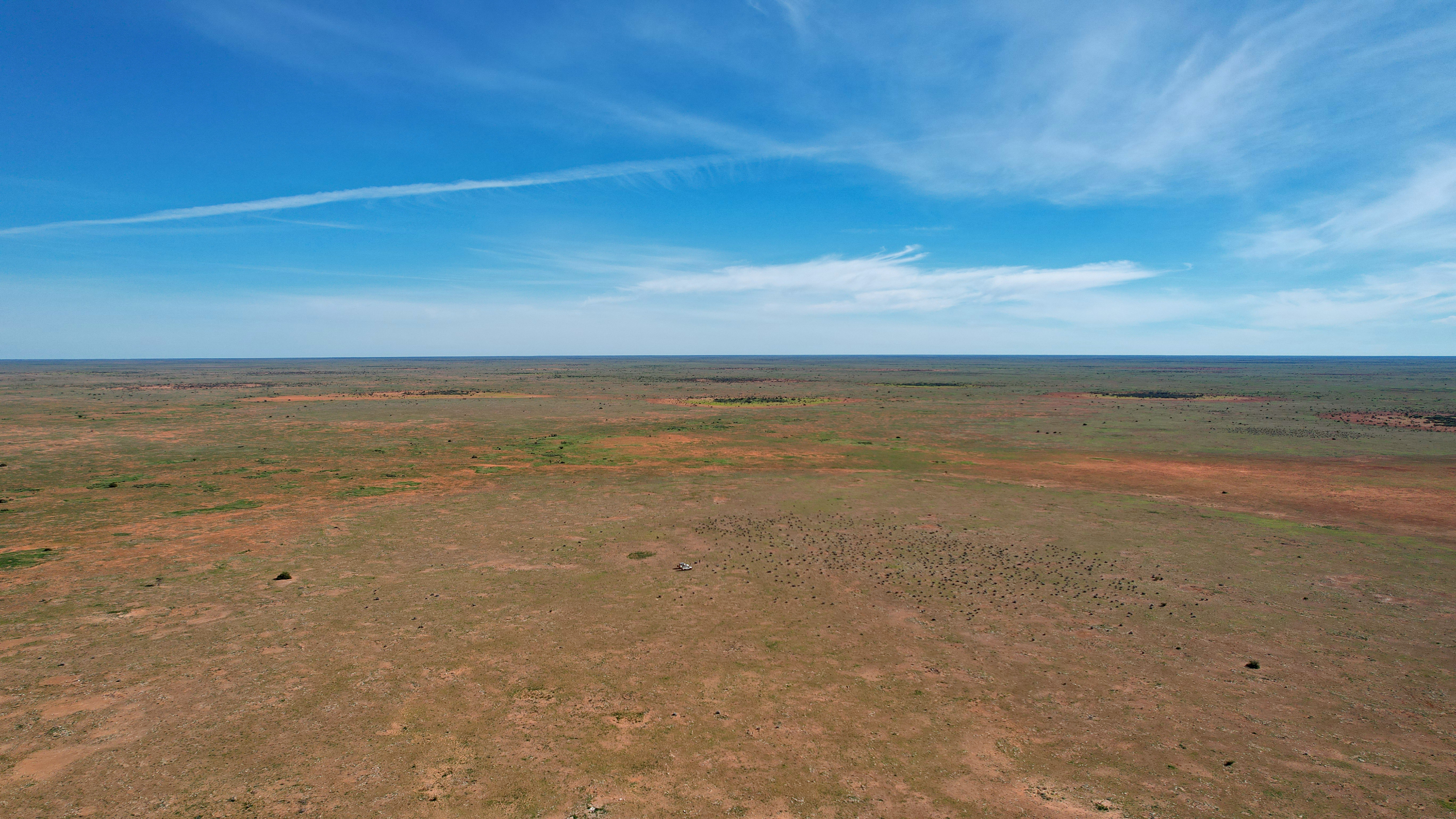
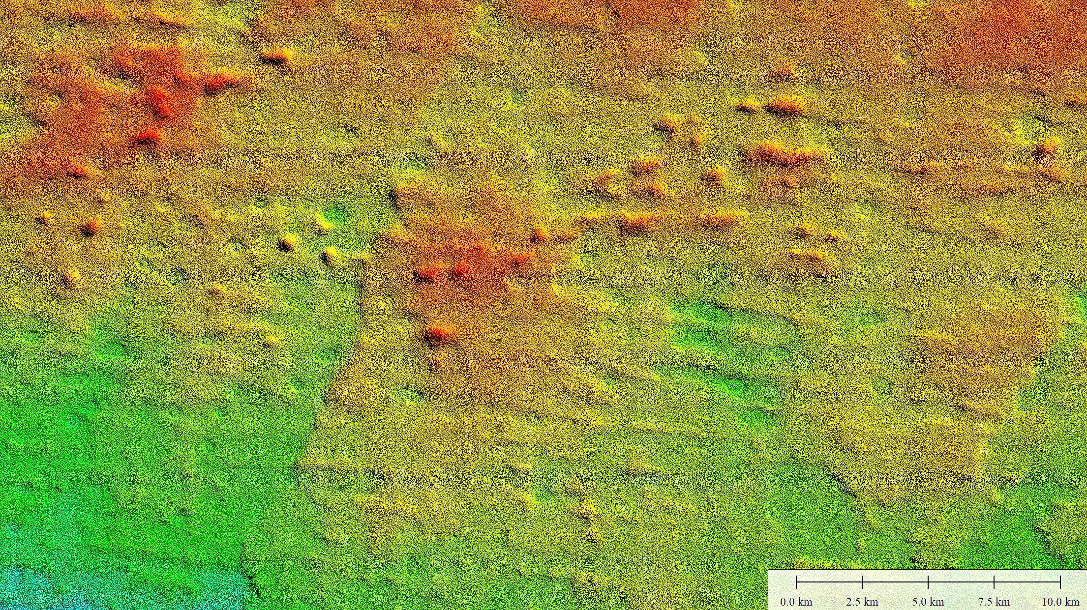
In 2022, we discovered a bioherm on the Nullarbor Plain with a diameter of approximately 1,300 m and a relief of about 10 m, representing a significant geomorphological anomaly on an otherwise remarkably flat surface. The occurrence of this feature as an apparently isolated landform represents a paradox, as bioherms typically form in clusters. For example, modern Halimeda bioherms on the Great Barrier Reef occur in extensive groups rather than as individual structures. Preliminary investigations conducted in 2024 demonstrated that bioherms on the Nullarbor Plain are in fact more common than initially assumed. The application of innovative satellite-based sediment moisture and evaporation mapping, adapted from methods developed for planetary research on Mars, revealed clusters of bioherms that are not detectable using conventional digital elevation models. These results confirm that Miocene conditions on the Nullarbor Plain were favourable not only for the growth of isolated bioherms but also for the development of an extensive reef system.
Work Package 1: Mapping of surface and subsurface topography
A – Mapping and spatial analysis of bioherms and other reef-related structures
A comprehensive and strategic investigation of the entire region will be undertaken to produce a detailed map of potential bioherms and associated reef structures. This analysis will provide precise morphometric parameters, including length and width, as well as information on spatial distribution and mutual spacing. These data will form the basis for predicting yet undiscovered bioherms in more geomorphologically complex parts of the plain.
Because relief on the Nullarbor Plain is minimal and aeolian sediments can locally smooth the surface by infilling depressions, a combination of spatial datasets will be employed. The primary dataset will be the TanDEM-X digital elevation model, complemented by potassium (K), uranium (U), and thorium (Th) radiometric imagery. These datasets enable differentiation between clay-rich sediments and exposed limestone, as clay minerals preferentially retain uranium and thorium due to their fine grain size and high surface area.
Recognising that radiometric imagery reflects only the uppermost centimetres of the surface, this limitation will be addressed through integrated satellite mapping of sediment moisture and evapotranspiration, which is particularly effective on the sparsely vegetated Nullarbor Plain. Variations in moisture conditions will allow identification of subsurface structures. Data will be analysed across different moisture stages, as contrasts between rock and sediment are most pronounced after rainfall, while prolonged dry periods highlight thicker sediment accumulations. The integration of these datasets will result in the first detailed map of the subsurface topography of the Nullarbor Plain.
B – Field-based surface and subsurface morphometry
The most prominent bioherms identified on digital elevation models will be surveyed in detail using unmanned aerial vehicles (drones). High-resolution imagery will be processed using photogrammetric techniques in Agisoft Metashape to generate accurate three-dimensional surface models.
To verify and supplement satellite-based interpretations, geophysical methods will be applied to investigate subsurface morphology. These methods will provide estimates of sediment thickness, detailed information on the subsurface geometry of bioherms, and constraints on their original dimensions. Electrical resistivity tomography (ERT) and seismic surveys will be employed, as high clay content limits the effectiveness of ground-penetrating radar.
Work Package 2: Lithological investigations
A – Sample collection
Bioherms will be sampled in the field and analysed to characterise their geological properties, with particular emphasis on identifying carbonate boundstone facies indicative of biogenic construction. Sampling will be conducted across multiple bioherms from south to north to examine stratigraphic variations in bioherm occurrence through time.
B – Laboratory analyses
Laboratory analyses will be carried out in collaboration with laboratories at ZRC SAZU and the University of Ljubljana. X-ray diffraction and X-ray fluorescence analyses will be used to identify mineral phases and stratigraphic trends. Petrographic thin-section analysis will provide insight into texture, structure, and the diagenetic history of the carbonate rocks.
Work Package 3: Timing
A – U–Pb dating of coral fragments
The age of bioherm formation will be constrained using U–Pb dating of coral fragments. Corals are characterised by high uranium concentrations and favourable uranium–lead isotopic ratios. Although traditionally considered unsuitable for open-system carbonates, recent developments in open-system modelling have demonstrated that U–Pb dating can yield reliable ages for corals. Dating of coral material associated with bioherms will allow precise determination of the timing of bioherm growth and improved stratigraphic interpretation of the Nullarbor Limestone.
B – Cosmogenic nuclide method for denudation rate estimation (³⁶Cl)
Long-term exposure of the Nullarbor Plain has resulted in spatially variable denudation, with higher rates in the south and lower rates in the north. To date, denudation estimates have been limited and largely indirect. The application of in-situ cosmogenic ³⁶Cl will enable direct quantification of long-term denudation rates. The flat topography, lack of vegetation, and arid climate of the Nullarbor Plain provide ideal conditions for the application of this method.
Work Package 4: Synthesis
A – Integrated synthesis
Data from all work packages will be integrated to interpret the development of bioherms within a Miocene barrier reef system. Morphometric, geophysical, and lithological evidence will be used to confirm the presence of multiple bioherms on the Nullarbor Plain and establish their relationship to reef development. Particular emphasis will be placed on linking bioherm morphology with palaeoenvironmental conditions. North–south comparisons will allow reconstruction of temporal patterns of bioherm formation and stratigraphic variability, as well as assessment of interactions between bioherms and karst processes.
B – Impact of the research
The results will contribute to a better understanding of Miocene coral reefs as key archives of palaeoenvironmental and palaeoclimatic change. Due to its exceptional preservation and specific environmental setting, the Nullarbor Plain provides a unique opportunity to study bioherms in a controlled geological context, largely unaffected by later tectonic or glacial modification. The research will have global relevance by expanding knowledge of ancient bioherms and their distribution, while the applied methods will serve as a model for future studies of carbonate platforms and reef systems worldwide.